All of us know the state, county, and street we live on and many of us know the plant communities that surround our homes, but do you really know your Ecological Address?
Known as ecoregions, those are areas of similar climate (rain and temperature), landform (river valleys, rocky outcrops, steep mountainsides), and soils. These characteristics are a major factor in determining the plant communities that occur across western North Carolina. Much like the U.S. Postal Service did in creating Zip Codes, scientists from across the country have defined ecoregions of the United States at four different scales. At Level I, most of the eastern U.S is within the Eastern Temperate Forest ecoregion. At Level II, western North Carolina is part of the ecoregion that includes the Appalachian, Ozark, and Ouachita Mountains (8.4 on the map).

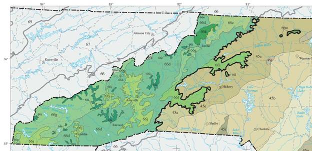
At the state level (Level III), the mountains of western North Carolina and eastern Tennessee are considered to be within the Blue Ridge ecoregion. Within theBlue Ridge, each of us resides in one of 9 Level IV ecoregions as shown on the map below. Most of us would immediately recognize the four major areas covering most of the region, but there are five minor ecoregions that stand out as having unique characteristics. These include the high mountains of Mount Mitchell, Grandfather Mountain, and Roan Mountain (66i on the map), the Eastern Blue Ridge Foothills (66l; Brushy Mountains, South Mountains), and the Amphibolite Mountains (66k; Rich Mountains). What many would be surprised to know is that the Sauratown Mountains in Stokes County (66m on the map) also are a part of the Blue Ridge ecoregion, but are not connected to it.

The Key to Ecoregions and examples of each type:
Level III – 66,Blue Ridge; 45,Piedmont
- Major Types within the Blue Ridge:
- 66c – New River Plateau (New River Basin)
- 66d – Southern Crystalline Ridges and Mountains (most of the region)
- 66g – Southern Metasedimentary Mountains (Great Smokey Mountains National Park and surrounding areas)
- 66j – Broad Basins (French Broad, Little Tennessee, Hiwassee Rivers)
- Minor Types within the Blue Ridge:
- 66e – Southern Sedimentary Ridges (Bald Mountains)
- 66i –High Mountains (Mt.Mitchell, Grandfather Mountain, Roan Mountain)
- 66k –Amphibolite Mountains(Rich Mountains)
- 66l –Eastern Blue Ridge Foothills (South Mountains, Brushy Mountains)
- 66m –Sauratown Mountains
You can find more details about your ecoregion address and download the full maps by going to the following web sites:
Level I and II – Ecological Regions of North America, a joint effort of Canada, United States, and Mexico. 2006. ftp://ftp.epa.gov/wed/ecoregions/cec_na/NA_LEVEL_II.pdf.
Level III and IV – Ecoregions of North and South Carolina. 2002. ftp://ftp.epa.gov/wed/
ecoregions/nc/ncsc_front.pdf.
-Jim Borawa, Senior Environmental Scientist
